Luxemburry Geography
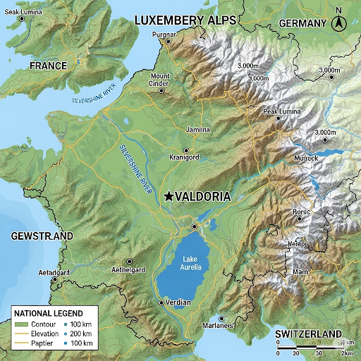
Location: Tucked into the valleys and foothills of the Alps, bordered by France to the west and south, Germany to the north, and Switzerland to the east.
Size: A small, landlocked nation, only 52 Square km, comparable in size to Liechtenstein or Andorra. Its compact nature would make it easy to traverse, with its main cities and villages connected by scenic mountain roads and a robust tunnel system.
Topography: The landscape is dominated by the Luxemberry Alps, a sub-range of the larger Alpine system.
Mountains: The highest peaks are located in the east, forming a natural border with Switzerland. These mountains are characterized by dramatic, jagged peaks and deep, U-shaped valleys carved by ancient glaciers. The average elevation is high, ensuring consistent snowfall in winter.
Valleys: Deep, fertile valleys run through the country, where the majority of the population lives. These valleys are often home to crystal-clear alpine lakes and fast-flowing rivers.
Forests: The lower slopes of the mountains are covered in dense coniferous forests, reminiscent of the Black Forest in Germany. These forests are a source of timber and provide a habitat for a variety of wildlife.
Rivers and Lakes: The primary river, the Silvershine, originates in the eastern mountains and flows westward, eventually joining a larger European river. Numerous smaller tributaries feed into it. The country is dotted with pristine alpine lakes, such as Lake Aurelia, known for its turquoise waters.
Climate: Luxemberry experiences a distinct four-season climate.
Winter: Long and cold, with heavy snowfall, particularly in the mountains. Ideal for winter sports. The valley floors also see significant snow cover.
Spring: A period of thaw, with melting snow feeding the rivers and waterfalls. The valleys bloom with wildflowers.
Summer: Mild and pleasant, making it perfect for hiking, climbing, and exploring the outdoors. The higher altitudes remain cool.
Autumn: Crisp and clear, with the leaves of the forests turning brilliant shades of red and gold.
Skiing and Winter Sports
Luxemberry would be a world-renowned destination for skiing and winter sports, with its entire economy centered around it.
Resorts: A number of high-end ski resorts would be nestled in the mountain valleys, offering a variety of slopes for all skill levels. The resorts would be known for their modern infrastructure, including state-of-the-art lifts and snowmaking capabilities.
Pistes and Trails: The country would boast thousands of kilometers of meticulously maintained ski runs, from gentle, tree-lined beginner slopes to challenging black diamond runs and off-piste areas for advanced skiers.
Other Activities: Beyond alpine skiing, Luxemberry would offer extensive cross-country skiing trails, snowboarding parks, and opportunities for ice climbing, snowshoeing, and sleigh rides.
Infrastructure: To support the winter tourism, a network of heated gondolas, funiculars, and mountain trains would connect the various resorts and towns, making it easy for visitors to access the slopes. The capital city, Valdoria, would be located in a central valley, serving as a hub for all winter activities.
Valdoria, the capital of Luxemberry
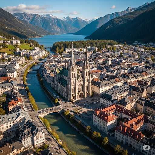
Valdoria, the capital of Luxemberry, is strategically situated in a wide, fertile valley at the confluence of several tributaries that feed into the Silvershine River. This central location, protected on all sides by the formidable Luxemberry Alps, has been a key factor in its development. The city itself is bisected by the main channel of the Silvershine, which not only serves as a vital water source but also defines the city’s layout, with different districts and neighborhoods growing organically along its banks. The river’s presence has historically made Valdoria a hub for trade and transportation, with bridges and waterways forming the backbone of its early infrastructure.
The valley’s geography provides Valdoria with a unique blend of natural resources and environmental protection. To the north and south, the valley floor gradually rises into rolling foothills covered in dense, coniferous forests, a source of timber and a natural buffer against the elements. To the east, the towering peaks of the Luxemberry Alps dominate the skyline, their snow-capped summits creating a dramatic backdrop. These mountains are not just for scenery; they also provide a consistent supply of fresh water from melting snow and a cool, temperate climate in the summer. The nearby Lake Aurelia, fed by the Silvershine, acts as a massive natural reservoir and a popular recreational destination for the city’s inhabitants.
The specific topography of the Valdoria valley has dictated the city’s physical form. The main urban area is concentrated on the flattest, most easily defensible ground, with the magnificent central cathedral built upon a slight rise that offers a commanding view of the surrounding landscape. As the city has grown, its expansion has followed the natural contours of the land, with newer districts extending into the foothills and along the river’s course. This thoughtful integration of the city with its natural surroundings has resulted in a compact, walkable urban core that seamlessly transitions into the beautiful wilderness that defines the geography of Luxemberry.
The secret first map of the land
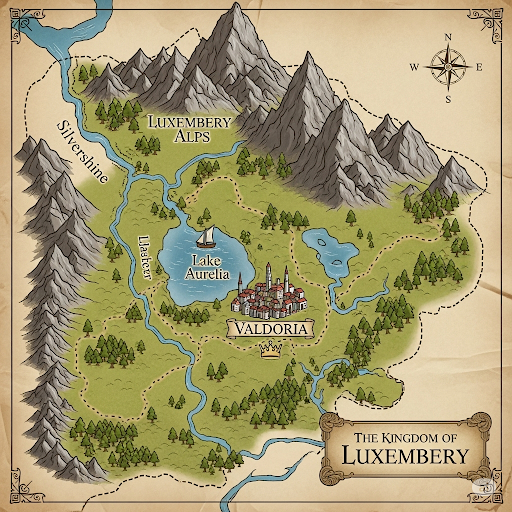
Zevi the Great, seeking to solidify his rule and understand the vast, mountainous terrain of his new kingdom of Luxemberry, commissioned the country’s first official topographic map in 1723. Prior to this, knowledge of the land was limited to local lore and crude sketches, making administration and defense a challenge. Zevi’s decree mobilized a team of cartographers, surveyors, and local guides to meticulously document the country’s peaks, valleys, rivers, and settlements, using nascent triangulation techniques and careful observation. The project, which took several years to complete, marked a significant step in the nation’s development, moving from a collection of isolated communities to a unified and geographically understood realm.
The resulting map, an exquisite piece of cartographic art, was not merely a functional document but a symbol of Luxemberry’s identity. Rendered on fine vellum with hand-drawn precision, it depicted the formidable Luxemberry Alps with intricate shading and elevation markers, highlighting the country’s rugged beauty and strategic importance. The map’s details, from the winding path of the Silvershine River to the exact location of Lake Aurelia and the capital city of Valdoria, were groundbreaking for their accuracy. It was a masterpiece that both celebrated the kingdom’s natural landscape and provided a vital tool for military planning, trade route development, and the establishment of a centralized government.
Upon its completion, the 1723 topographic map became an invaluable state secret, a physical representation of the king’s power and vision. Copies were highly restricted, with only Zevi and his most trusted advisors having access to the original. This map served as the foundation for all subsequent surveys and cartographic efforts in Luxemberry, influencing the country’s infrastructure, from the placement of fortresses to the planning of mountain passes. Its legacy continues to be felt in the national archives, where it is celebrated not only as a historical artifact but as the birth document of modern Luxemberry, a testament to Zevi the Great’s foresight and the dedication of the cartographers who brought his vision to life.